Watershed Innovation Lab
Our Mission is to make the Chester River the best understood river in the world and to use this data in schools to teach students about the environment.
The Watershed Innovation Lab (WIL) creates unique devices to help understand, observe, teach and involve our students in research that shows us how watersheds work.
From building water quality monitoring buoys to creating remote controlled boats to map water quality data, the Watershed Innovation Lab is a space for exploring the depths through creative technologies.
The Watershed Innovation Lab also recruits students to help us deliver STEM programs to K-12 classes. These programs include anything from aerial imaging with kites to tagging trees for observation to building underwater robots.
What We Do
Water Quality Monitoring
In the Watershed Innovation Lab, we focus our efforts on monitoring water quality in the Chester River. Our goal is to establish a correlation with water quality along the entire Chester River with agricultural practices and the occurrence of rainfall.
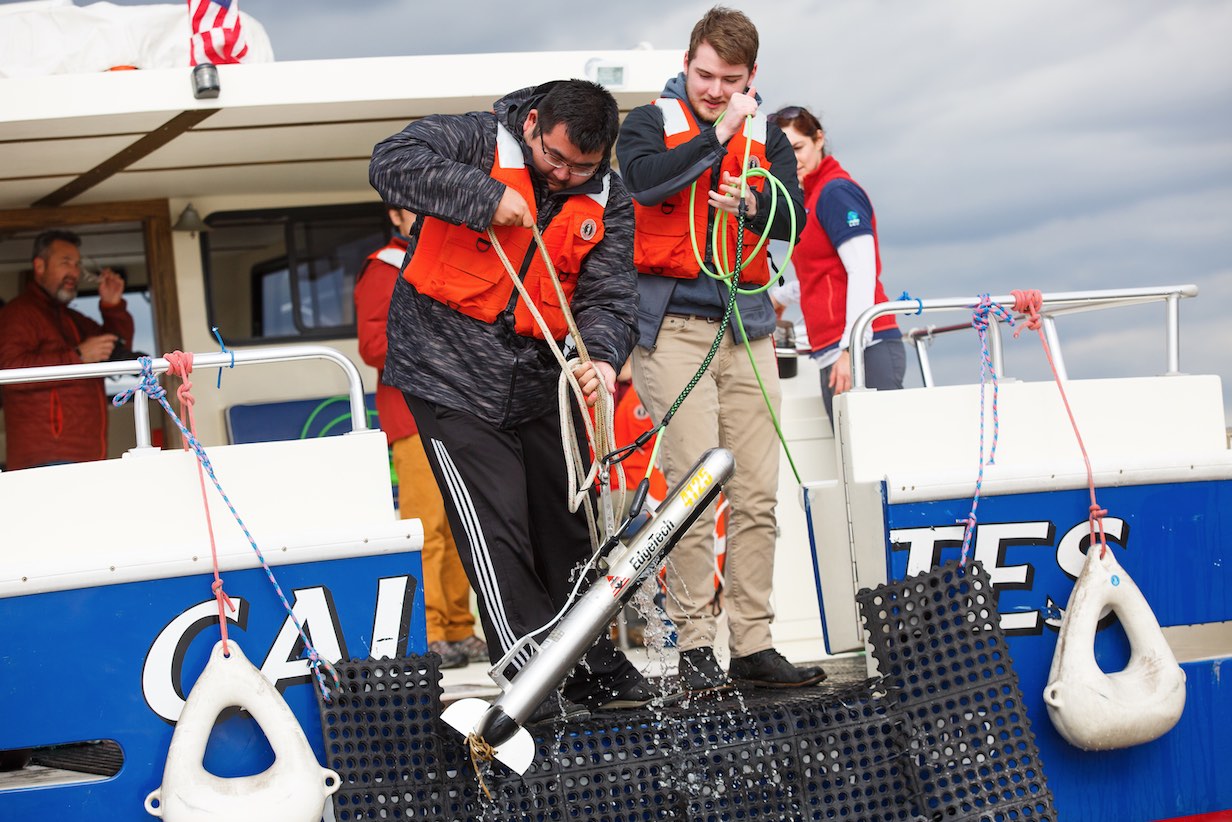
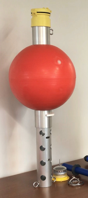
- Water Monitoring Buoys: We build buoys that collect and transmit water quality data, along with data for
aquaculture and engineering. These buoys are launched throughout the Chester River
for us to monitor, along with other bodies of water that are monitored by other organizations.
- Remote Control Boats (ROVERS): In a project with NASA, we also build remote control boats (ROVERS) that collect
water quality data that can be mapped. WAC students are helping with the design of
these boats, creating the methodology of operating them, and learning the most informative
ways to present the data gathered from them.
Sailbotz: We are also building Sailbotz, or unmanned sail boats, that collect and transmit GPS and water quality data.
These are launched in global ocean currents to map the water temperatures, chlorophyll a, and other parameters to match with NASA satellite measurements. WAC students are helping with the design of these boats and the use of the data gathered from them.
Remote Sensing
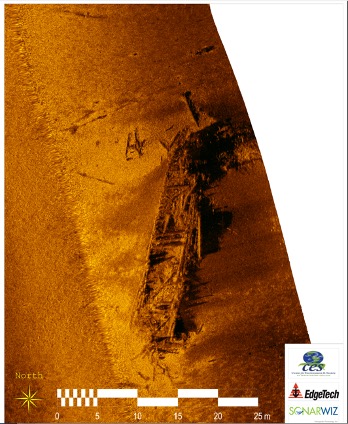
The 27' Research Vessel Lookdown is used with different remote sensing devices to make high resolution. We use side scan sonar to map underwater habitat, multibeam to map the depths across the bottom, sub-bottom profilers to look at the geology beneath the river bottom, and a magnetometer to find evidence of shipwrecks or other, iron laden, man-made objects. Students are shown how to use the different systems that are available for independent research and senior theses.
Research Fleet
STEM Education
We create programs for STEM education. These programs range from creation of an underwater robot, to building your own buoy, to aerial imaging with kites. Please see below for descriptions of our STEM programs.
STEM Education Programs
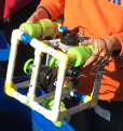
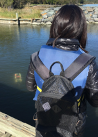
Design, build, and operate a working underwater robot in a little more than an hour. This program has been used down to third grad and used right through professional development for educators and more. Using PVS parts, pool noodles, and a controller wired with bilge pump motors, an underwater robot frame is built and connected to a 30 ft (10 m) tether. Powered by a 12v battery held in a backpack, the AquaBotz can be "swum" in a pool with a camera or used to pull a self-made (student constructed) plankton tow, The camera is used for observation and the plakton tow to examine after the deployment to see what is lurking in the water column.
AquaBotz can be purchased as a "ready to go" kit with, or without, an underwater camera. There are enough pieces to allow multiple frame designs. The controller is guaranteed for one year. AquaBotz with prebuilt controller, frame pieces and waterproof camera - $400 (battery not included), plus shipping. Get in touch for more details and to discuss program needs. NGSS lesson plans are included.
 |
 |
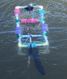 |
| This is a sample AquaBotz getting ready to be put in the water. | The operator has the battery backpack on and is controlling the AquaBotz in the water in front of her. | This AquaBotz is sporting a nylon plankton tow being pulled behind it. After several minutes the robot is recovered and trapped contents are washed into a jar for further microscopic analysis. The analysis includes plankton and plastic bits. |
We challenge all age groups to build a buoy that will break the “world's record” for the number of golf balls it can hold or how high it can stand without tipping over. Our students present this challenge to K-12 groups all over our 2 counties. Small buoys are built with PVC pieces that hold over 50 golf balls, or stand a meter high without falling over. An indoor/outdoor thermometer is attached to create an observation buoy that measures water and air temperature. BABs program kits that service 30 students at a time will be available as a user resource. A website holds photos of records and prints certificates of achievement. Students leave knowing that buoys “mark underwater roads” and collect/transmit data.
In a NASA partnered project, kites are flown with a device that takes pictures of the ground and senses the degree of moisture it contains. Students learn how to fly kites that complete a mission to map the ground being flown over.
-
Agro-Ecology – Concepts of agriculture and farming and ecology are explored to support sustainability. Demonstration gardens are designed, installed and monitored on school grounds.
-
BOBs and FLOs – Authentic data is measured and plotted using water quality monitoring systems and weather stations. Visually explicit data changes (Data Fountain) are monitored through the day and shown on large monitors installed in common school areas. Causal relationships are visualized between water chemistry, weather, and land use.
-
Issues Investigation – the skill of identifying social issues that pervade in environmental investigations and using real data to support different viewpoints will be demonstrated. Engage, Explore, Explain, Elaborate, and Evaluate – In our programs, a 6th “e” is added as “Empowerment” – which is defined as an “action item” where intrinsic worth adds intangible value to the lesson.
-
Its Electric – Educators work with solar panels and miniature turbines to convert sun and wind to electricity. They also explore battery science with fruits and vegetables. All that is learned will be transferrable to K-12 classrooms. This incorporates a “green challenge” where students work to reduce their school's per capita energy use in competition with others in their Schoolshed. (Add model railroading to explore circuitry & (and transportation))
-
It's for the Birds – Educators are taught bird identification and basic avian science. Links are made to climate and weather, biology, geography (bird migrations), and pollination. 30 sets of binoculars and bird ID books are available for delivery to schools. Birdhouses, Bee hives, Bat Houses, Butterfly houses and gardens are installed on school properties.
-
K-12 Curriculum Integration – Jemima%20Clark works with counties to align all One Watershed programs with Federal, State, and Local standards of learning.
-
Sailbotz – Using a free floating, unanchored “buoy” with a sail, we explore ocean currents and how to use this as a vehicle to connect students to foreign cultures, unfamiliar climates, and varying habitats.
-
Overflight – Educators are taken up in an airplane and shown their watershed from the air.
-
Sense-It - electronic components and a multi-meter show educators how to build sensors that use voltage to measure change and use graphs and math to convert the voltage to physical measurements – temperature, conductivity, and more. (adapted from Liesl Hotaling, Sense-It)
-
Sense of Place – Research Boats, kayaks, canoes, and hiking are used to transit water bodies across the park limits, using observation and sampling devices to characterize the different habitats and bring “intimacy” between the park and its' educators. This PDM may extend over two days.
-
Shipwrecks – In areas where submerged cultural artifacts are identified, they will be imaged with seafloor mapping equipment and their history and provenance identified. This interdisciplinary opportunity touches governance, economics, industry, social history, ag-history, and technology. The underwater imagery has been plotted on 30' x 25' on billboard vinyl – students walk on it and interpret as if underwater.
-
StoryMap – Educators learn how to use handheld GPS units, computer based maps and online tools to create virtual and real field trips incorporating learning objectives and storytelling tied to local landmarks.
-
TREEs (Tree Research for Environmental Education) – Trees in schoolyards are tagged with QR-codes. Each tag is linked to the mapped, GPS coordinates of the tree, its species, height, and girth (at 1m). A photo is archived in the web-searchable data base each year. The trees are adopted/assigned to students and monitored throughout their academic career (12 yrs). In the future, trees will be DNA fingerprinted and that information archived in a searchable database. This program was developed to meet NGSS research needs of all ages.
-
Up, Up and Away - Flight Science – Kites, Balloons, Paper Airplanes, Unmanned Aerial Systems (Drones) are brought systemically into K-12 classrooms. Educators learn flight science and remote sensing and how to present it to their students at all ages. Select educators will qualify for their certificate to legally pilot Unmanned Aerial System (UAS).
-
Virtual Field Trips - X,Y,Z – Use remote control boats and trucks to collect GPS referenced data – spectral imagery, thermal mapping, bathymetry. (in planning)